Glen Canyon Bridge...
A Vital Link Between Two States

Glen Canyon Bridge
Photo: US Bureau of Reclamation
Glen Canyon Bridge, like many things in life, was born out of necessity, and it all started through an Act of Congress.
On April 11, 1956 the U.S. Congress authorized the construction of Glen Canyon Dam to be located on the Colorado River approximately 17 miles north of Lee’s Ferry, Arizona and 12 miles south of the Arizona-Utah border.

Future Site of Glen Canyon Bridge and Dam
Photo: USBR
In 1956 this location was pretty much in the middle of nowhere. There was no railroad here and the nearest towns of any size were Flagstaff, Arizona, 130 miles to the south, and Kanab, Utah, 73 miles to the north.
To further complicate things, there were no roads from the dam site to either of these towns and, there was no way across the deep chasm formed by the Colorado River.
So how can you build a dam where there are no roads and you have no way of getting from one side of the river to the next? You build roads and a bridge. Thus, Glen Canyon Bridge was born out of necessity.
|
|
The Roads In 1956 when the dam was authorized by Congress, US Highway 89 extended north from Flagstaff, Arizona to Bitter Springs, Arizona, a distance of approximately 106 miles. The Bureau of Reclamation contracted for a road to be built from that point to the dam site, a distance of approximately 24 miles. The Bureau of Roads was to build a temporary paved road from the west side of the dam site to the Arizona-Utah state line. Then, the state of Utah would build a paved road from the Arizona-Utah state line to join Utah State Highway 136 at Kanab, Utah. Thus, there would now be a road all the way from Flagstaff, Arizona to Kanab, Utah. Now that the problem of getting to the site had been resolved, there was still the obstacle of getting across the 1,300-feet chasm. |
|
Until Reclamation could come up with a solution, the contractors were faced with a trip of more than 190 miles to get from one side of the canyon to the other. When considering how to do this, Reclamation first looked at running the road over the dam itself. However, this presented some new problems: |
Books about the Glen Canyon Bridge may be purchased at the Carl Hayden Visitor Center, or you may purchase them through Amazon.com by clicking the link below.
|
• The crest of the dam would be more than a hundred feet below the canyon rim.
• The width of the crest of the dam was only 25 feet; potentially creating a traffic hazard.
• The curvature of the dam presented further access problems.
• Finally, the dam would have to be built first before the two roads could be linked.
For these reasons, Reclamation decided to build a separate bridge. But, then the question arose as to what kind of bridge should be built:
• A wooden suspension bridge to be used only for the construction of the dam at a cost of approximately $3,020,000, or
• A permanent arch-type bridge with an estimated cost of $2,920,000.
Wisely, they decided on the second option.
The Glen Canyon Bridge was designed by Robert Sailer, who was the Head of the Bridge Section in Denver for the US Bureau of Reclamation.
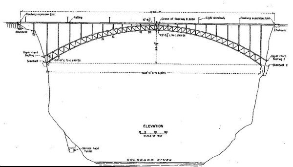
Glen Canyon Bridge
Graphic: US Bureau of Reclamation
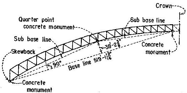
Bridge Specifications:
• Deck arch
• Two-hinged truss type, with a span of 1,028 feet.
• Rise of the span is 164 feet 8 ¾ inches
• Bridge deck is 700 feet above the Colorado River
• The bridge has a 30 foot roadway
• There is a 4 foot sidewalk on either side
• The bridge deck is a 6-inch thick reinforced concrete slab
• The bridge contains 3,920 tons of structural steel
• Each half of the arch is over 500 feet
• Distance between upper and lower chord at the skewback is 37 feet
• Distance between upper and lower chord at the crown is 20 feet and ¼ inch
• Crown of roadway elevation 3,828
“In the authorization, appropriations, specifications, original drawings, etc, this bridge was identified as the Colorado River Bridge. However, in 1959 the bridge was officially named the Glen Canyon Bridge as an aid in obtaining a more precise location identification.”
On December 18, 1956, the Bureau of Reclamation opened the bids to build and erect the bridge.
On January 1, 1957 the contract for building the bridge was awarded to Peter Kiewit Sons and the Judson Pacific Murphy Co, a joint venture known thereafter as Kiewit-Judson Murphy.
Their bid was for just over $4,000,000; $1.2 million over the amount estimated by Reclamation’s engineers.
On January 28, 1957, Reclamation issued the order to proceed, and construction on the Glen Canyon Bridge began on Valentine’s Day, February 14, 1957.
Judson Pacific Murphy Co would fabricate the bridge at their plant in Emeryville, California, pre-assemble it to ensure perfect fit and do any reaming that was necessary. The bridge would then be disassembled and trucked to the bridge-site, one half to each side.
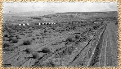
Trailercamp ,Soils Lab, Light Plant, Fld Engr Ofc
Photo: US Bureau of Reclamation
Initially, the field offices and a few trailers for the construction workers were located on the west side of the river, so one of the first things that had to be done was to build a temporary bridge to get the workers and equipment from one side of the canyon to the other.
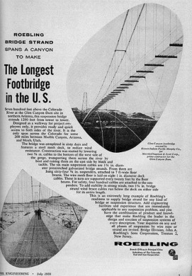
Roebling Ad in the July 1958 Issue of Civil Engineering
|
Roebling Steel Co located in Florence Township, NJ, manufactured steel wire and cable, until it closed in the 1980's, and provided the cable for the walkway. The following description is from their ad in the July 1958 issue of Civil Engineering: “The bridge … features a steel mesh deck, to reduce wind resistance. Construction was started by lowering two 5/8 in. cables to the bottom of the west side of the gorge, transporting them across the river by boat and raising them on the east side by block and tackle. The six main suspension cables are 1 3/4 in. diameter prestretched galvanized bridge strands. From them are hung sixty-four 5/8 in. suspenders, attached to 7 ft-wide floor beams. The wire mesh floor is laid on eight 1 in. diameter deck cables. |
These in turn are supported every twenty feet by the floor beams. For safety, four handrail cables are attached to the suspenders.
To add stability in strong winds, two 1 3/4 in. bridge strand wind brace cables run below the deck on either side for its length."
The 12 1/2 ton capacity cable way was built in 60 days, and, at the time, was the longest footbridge in the United States.
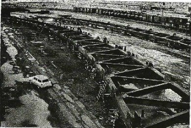
Preassembled Bridge Arch at Judson Pacific Murphy Co
Emeryville, California
Photo: US Bureau of Reclamation
At the Judson Pacific Murphy Co plant in Emeryville, California work was being carried out on the fabrication of the bridge itself.
One Half of the Bridge Arch
US Bureau of Reclamation
In the meantime, in March of 1957, work had begun on excavation for the pedestal and abutments ( also known as skewbacks) on both the east side and the west side of the canyon. By May, the excavation for both abutments and the pedestal on the east side had been completed.
However, as often happens, the best laid plans of mice and men don’t always go as planned. In excavating for the abutment on the west side, the wall was found to be structurally unsound.
To resolve this problem, Mountain States Construction Company, who had contracted for digging the right diversion tunnel for the dam, removed almost 9,000 cubic tons of material. The void was then filled with concrete.
In order to place and support the bridge arch, two 1,540 foot 25-ton capacity cableways with tie-backs were erected. Each section of the arch would be lifted into position then held in place by tie-backs.
As the arch moved out from the canyon wall, tie-back cables were attached to each newly placed section and removed from sections which had previously been placed.

Glen Canyon Bridge Final Chord
Photo: US Bureau of Reclamation
This process took place on both sides of the canyon until on August 11, 1957 the lower chord from each side was “allowed to come together and bear the load of the arch.”
After a three day waiting period, to allow the temperature throughout the arch to become fairly constant, the final sections were joined together on August 14, 1957.
“Final measurements showed that the builders were off their final assembly by only ¼ of an inch – far less than the 8 inches allowed for in the design.”
|
|
|
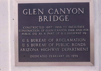
Glen Canyon Bridge Dedication Plaque Photo: USBR |
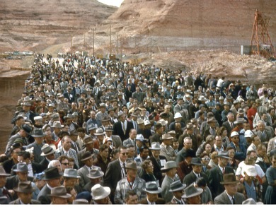
Dedication Ceremony Photo: USBR |
The bridge was dedicated February 20, 1959. The dedication was attended by Governor Paul Fannin of Arizona, Governor George D. Clyde of Utah, along with other state and federal dignitaries.
“A torch was used to cut a chain ribbon to dedicate the bridge. . .and hundreds of people made the trip to peer down into the spot where a dam would rise.”
Amazingly, this project of magnificent proportion was accomplished in just over two years from the time construction began on February 14, 1957 until it was dedicated on February 20, 1959.
Floyd Dominy, former Commissioner, Bureau of Reclamation in an interview with Ken Verdoia of PBS, I think said it best when referring to the Glen Canyon Dam project:
“Glen Canyon Dam was authorized in april {sic} of 1956…. And we actually started construction within six months. Why today we'd spend six months trying to find out where to put the toilets for the rock scalers."
For anyone interested in learning more about the Glen Canyon Bridge, please see some of the references listed below.
Comments and Suggestions
I started this website in February 2011, and, quite honestly, it has not lived up to my hopes and expectations.
I would appreciate some honest appraisals and suggestions as to how to improve it.
References and Resources:
Technical Record of Design and Construction
Glen Canyon Dam and Powerplant
Prepared by the Bureau of Reclamation.
http://www.gcmrc.gov/library/reports/other/Power
/BureauOfRec1970.pdf
http://www.usbr.gov/projects
//ImageServer?imgName=Doc_1232657383034.pdf
Jedidiah Rogers Glen canyon Unit USBR
http://digital.lib.lehigh.edu/fritz/pdf/251_16.pdf See pg 48
http://www.modernsteel.com/archives/PDFs_61-90/1975A9_15-2.pdf
Special Collections & Archives
Northern Arizona University Library
http://archive.library.nau.edu/cdm4/item_viewer.php?CISOROOT=/cpa&CISOPTR=22835&CISOBOX=1&REC=5
Glen Canyon: a Dam, Water and the West
Produced and Directed by Ken Verdoia
www.kued.org/productions/glencanyon/script/script.html
Lake Powell Chronicle
http://www.lakepowellchronicle.com
/V2_news_articles.php?heading=0&story_id=468&page=80
Highest Bridges
highestbridges.com
Return From Glen Canyon Bridge To Lake Powell Country

© Copyright 2011-2013. Lake-powell-country.com
All rights reserved
No reproduction allowed without permission