Navajo National Monument Has A History Of Intrigue, Mystery And Serendipity

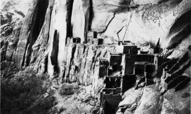
Betatakin Cliff Dwelling Navajo National Monument
Photo: National Park Service
Navajo National Monument is a hidden jewel in Lake Powell Country.
Although it is not as strikingly beautiful as Canyon de Chelly nor as iconic as Monument Valley, it is a gem worthy of inclusion in any crown.
The Monument is tucked away in remote northern Arizona between Page to the west and Kayenta to the east, and surrounded entirely by the Navajo Reservation.
By executive order under the 1906 Antiquities Act, it was made a National Monument by President William Howard Taft on March 20, 1909.
This was in response to claims by early archaeologists and bureaucrats from the General Land Office in Washington that pothunters were damaging and pillaging the area around Kayenta, Arizona.
Navajo National Monument is made up of three non-contiguous sections.
The main section, is known as Betatakin and is named after the major cliff dwelling located within 160 acres of National Park Service land.
It, also, includes a 244.59-acre section which falls under a land agreement with the Navajo Nation.

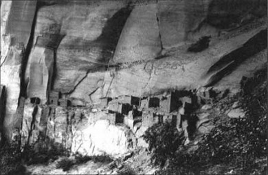
Keet Seel Cliff Dwellings
Navajo National Monument
Photo: Wikimedia Commons
The Keet Seel (sometimes spelled Kiet Siel) section, is, as the crow flies, about eight miles from Betatakin.
It is named for the large cliff dwelling located within its 160-acre boundary.

Inscription House As It Appeared In 1941
Navajo National Monument
Photo: National Park Service
Inscription House, the third section, is located in Nitsin, about forty miles away.
It is the only one of the three that is now closed to the public.
My first visit to Navajo National Monument was in the fall of 1989 when my nine year old granddaughter, Elizabeth, and I stopped there on our way back from a trip to the Grand Canyon.
We spent the night at the monument's campground in my 1985 VW campervan.
The weather was perfect and we were the only ones there.
We were up early the next morning, had breakfast and headed up to the Visitor’s Center which was still closed.
That was ok with us as we were more interested in exploring than in visiting the center.
The NPS had, and still has, interpretative signs along the trail leading to the Betatakin Ruins Overlook.
We followed this trail, stopping at the signs where we learned about the Utah juniper, a bush called Mormon Tea, the pinon pine and much more.
At the end of this trail, which is now called The Sandal Trail, we had a beautiful view of the Betatakin Ruins, tucked under a ledge across the 560 foot deep Betatakin Canyon.
|
Betatakin, in Navajo, means “House Built on a Ledge.” Not as breathtaking as the Grand Canyon, but still impressive. In fact, it was hard to imagine that the Anasazi who had built and inhabited the dwellings were thought to have left sometime around 1286 AD. |
Books and Maps about Navajo National Monument may be purchased at the Visitor Center, or you may purchase them through Amazon.com by clicking the link below. Navajo National Monument |
Impressive, indeed!
From the overlook it is difficult to get a proper perspective of the enormity of the Ruins.
From here it looks small. But in reality the alcove in which it is located is 452 feet high and 370 feet across.
Not your typical condo.
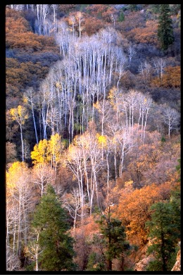 Aspens In Betatakin Canyon |
Another trail Elizabeth and I followed was The Aspen Trail. This is a steep, one mile round trip trail to an overlook of an old Aspen grove in the bottom of Betatakin Canyon. The aspens were in their glorious fall colors and I took the picture shown on the left. I had the image enlarged to 20 x 40 and entered it in the New Mexico State Fair Photo Contest where it won second place. |
Kayenta, AZ Current Weather and Forecast
The National Park Service gives two guided tours to the Betatakin Ruins, both of which are free:
• 8:15 A.M. - This is a strenuous 5-mile round-trip which takes about 3 to 5 hours to complete.
You are not allowed to make this trip on your own and need to sign up for it at the Visitor’s Center where schedules are posted.
They are limited to 25 people, so be sure to sign up early.
• 10:00 A.M. – This is a very strenuous 3-mile round-trip which takes about 3 to 4 hours to complete and is limited to 15 people.
It starts behind the Visitor Center, goes along the Sandal Trail, then to Aspen Trail and down to the canyon bottom, a difference in altitude of about 700 feet.
For either of these trips, you should carry at least 2-3 liters of water, and you should wear sturdy but comfortable shoes.
These tours are not for the weak and infirm.
The National Park Service cautions that if you have knee, hip, respiratory or heart problems you should not take either of these guided tours.
If you are thinking of taking the Betatakin Trail Tour, I recommend you download the pdf file below:
http://www.nps.gov/nava/planyourvisit/loader.cfm?csModule=security/getfile&PageID=562328

Keet Seel Cliff Dwelling Navajo National Monument
Photo National Park Service
Keet Seel, “Broken House” in Navajo, is considered by many to be one of the largest and best preserved ruins in the southwest.
The ruins consist of more than 150 rooms and 6 kivas, as well as several rooms thought to be used for storage.
All of these were located within an alcove 350 feet by 50 feet.
Archaeologists believe that as many as 150 people lived there at one time.
|
Keet Seel is only open to visitors from around the end of May until about the second week in September. As there are no roads leading to the ruins, the only way in is to hike into the area. The trail is primitive, rugged and strenuous and takes about 4-6 hours hiking time each way. You will, also, need to allow time for breaks and for the guided tour of the ruins. For those reasons most people opt to spend the night there and hike out the next day. |
Primitive campsites are located about ¼ mile from the ruins.
Composting toilets are available, fires are not permitted and there is no safe water.
Plan on carrying at least a gallon of water per person per day.
Before hiking to Keet Seel, you must first make an advance reservation which can be done by calling (928) 672-2700.
Reservations are not accepted for more than 5 months in advance, and the number of people allowed to visit the ruins each day is restricted to 20.
Once you have made your reservation, you must then attend a trail orientation where you will be given your backcountry permit.
The orientations are at the Visitor Center and are scheduled for twice a day; one at 8:15 A.M. of the day of your hike and the other at 3:30 P.M. the day before your scheduled hike.
Once you arrive at the ruins, you are required to register with the park ranger to arrange a guided tour.
You are not allowed to enter the ruins without a guide.
If you are considering visiting Keet Seel, I strongly recommend you download a pdf file at:
http://www.nps.gov/nava/planyourvisit/loader.cfm?csModule=security/getfile&PageID=562492

Inscription House National National Monument
Photo National Park Service
Inscription House is the third ruins within the Navajo National Monument.
Its name comes from the Spanish inscriptions on one of the dwellings dating back to 1661.

Inscription House Navajo National Monument
Photo Courtesy National Park Service
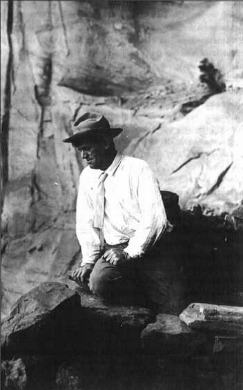
John Wetherill, who “discovered” this ruin in 1909, said later that the inscription was “ C M O S 1661 ADn ” and may have been 1861 instead of 1661.
For more on John Wetherill, go to the History section below and also see my page on Rainbow Bridge.
This is the smallest of the three ruins. It has 74 rooms, one kiva and few grainaries.
The dwellings were partially constructed of adobe (blocks made with mud and generous amounts of grass.)
The ruins are set inside an alcove at the base of a towering sandstone wall, which helps to protect the dwellings from the weather.
Inscription House has been closed to the public since 1968 due to its fragile condition and remote location.

Directions To Navajo National Monument:
To reach Navajo National Monument, drive east from Page, Arizona on SR 98 to Hwy 160.
Approximately 6 miles east of Page, you will come to Navajo Route 22B leading to Antelope Point Marina.
At this junction is the Navajo Generating Station which supplies electricity to Arizona, Nevada and California.
As you continue east, take note of the Lake Powell and Black Mesa Railroad which runs between the power plant and the Kayenta coal mine.
The train that runs on this railroad line is powered by the electricity generated at the power plant.
Just to the east of the end of the railroad line is the junction of Hwy 160 and SR 564.
Turn left, to the north, on SR 564.
From this point, it is only about 10 miles to Navajo National Monument and you will get a small taste of what you can expect once you arrive.
This is beautiful country with pinon pine, Utah juniper and shrub cedars trees sprinkled among the sandstone.
There are several nice views of Tsegi Canyon and you may want to make a few stops along the way to take photographs.
Navajo National Monument has a Visitor’s Center, a museum and two free campgrounds located near the Visitor’s Center.
There are no entrance fees and all guided tours are free.
Visitor’s Center Hours:
Summer hours: The summer season starts around the end of May and ends the second week of September.
The visitor center is open 8 A.M. to 5:30 P.M. every day.
Winter hours: The winter season starts the first of October and ends the third week of September.
The visitor center is open 9 A.M. to 5 P.M. every day.
Sunset View campground will be open, as will the three self-guided overlook trails Sandal Trail, Aspen Trail and Canyon View Trail.
Important Time Change:
Arizona, unlike most of the United States, does not observe Daylight Savings Time (DST).
However, because part of the Navajo Tribal Land is located in the states of Colorado, New Mexico and Utah, which do observe DST, the Navajo Nation and Navajo National Monument DO observe DST.
Therefore, from March through November, all time on the reservation and the monument are one hour ahead of the rest of Arizona.
Climate at Navajo National Monument:
Monument Valley is at 7300 feet and this altitude always plays an important role in shaping the weather here.
Snowfall can be heavy in the winter months and it is not uncommon to have snow in the spring.
Spring can be blustery, and thunderstorms in July and August can bring heavy rain and flash-floods.
Spring: Cool with temperature Lows in the 30’s and 40’s and Highs in the 50’’s and 60’s.
Summer: Warm to Hot with temperature Lows in the 60’s and Highs in the 80’s and 90’s.
Fall: Pleasant but cool, with temperature Lows in the 30’s and 40’s and Highs in the 60’s and 70’s.
Winter: Very cold and snowy, with temperature Lows in the 20’s and Highs in the 40’s.
Camping at Navajo National Monument:
Canyon View Campground:
Open April 1 through September 30.
This campground, on an unpaved road, has 16 sites, three of which are good for group camping and can be reserved by calling (928) 672-2700.
There are composting toilets, charcoal grills, but no water. There are fine canyon views on both sides.
Sunset View Campground: Open All Year.
This Free campground has paved roads, 31 small sites with picnic tables, charcoal grills, and parking spaces.
There are restrooms and running water available, but no hookups.
RV's are limited to 28 feet or less.
The sites are available on a first-come, first-served basis.
Nearby Lodgings:
The closest lodging to Navajo National Monument is in Kayenta, Arizona which is located about 20 miles to the southwest.
Kayenta bills itself as the gateway to Monument Valley and, because of its proximity to this highly popular tourist attraction, advance reservations are a must.
As with many other things in life, all motels are not created equal.
There are the good, the bad and the ugly.
Therefore, I would suggest, before making any reservations, you use the box below to determine:
• which accommodations are available for the dates you need
• which have the best available price
• which have the best traveler reviews.
Doing this could save you money and keep you from having a bad experience.
This is not a Booking Agency. Rather it is a search engine designed to help you find available lodging in Kanab, Utah on the dates you select and for the best possible price.
They search through their data base of the 30 biggest booking sites looking for motels with accommodations available for your selected dates.
The results of this search are then brought back to you with all the information you need to make an informed choice.
To use this service to find lodging at Kayenta, Arizona simply go to the little box below:
• Enter the dates you need
• Enter the number of guests
• Enter the number of rooms required
• Click "Search"
•
...and you will be taken to a list of Kayenta, Arizona accommodations
available for those dates, along with the best price for each one of
them.
(Page opens in new window.)
Once you have a list of hotels, simply click the ones in which you are interested.
Once you have a list of hotels, simply click the ones in which you are interested.
For each hotel, you will be given a General Overview plus a number of quality images of the hotel.
Additionally there will be a listing of Hotel Features, such as basic amenities, what additional services are available and check in and check out times.
There will, also, be FAQ’s, and Guest Reviews.
All the information you need in which to make an informed choice.
Only after you click "Select" on the hotel of choice, will you be sent to a regular booking site.
Until then, you remain with the Search Engine.
Finding and selecting lodging has never been easier.
Have A Great Story To Share?
Do you have a great story about this destination? Share it!
History:
The history of Navajo National Monument is one of intrigue, mystery and serendipity.
Evidence found near Navajo Mountain, which is located just a few miles to the west, suggest that the area was inhabited as far back as 10,000 years ago.
These people were hunters and gatherers and lived in temporary brush shelters or lean-tos.
They moved frequently with the seasons as they followed the movement or migration of game and the maturation of edible plants.
It wasn’t until they learned to plant and grow corn and squash that they were no longer dependent upon the game in the area nor had to move as frequently in search of edible plants.
This probably occurred somewhere around 500 B.C..
Over the next 1,000 years, these people, called Basketmaker II by archaeologists, became more sophisticated.
As the name implies, they learned to make baskets as well as weapons, clothing, textiles, and other similar items, using a wide variety of materials.
As they became more and more agrarian, they no longer needed to move from place to place in search of food.
Instead they moved with the seasons, from a summer home to a winter one and back again.
Archaeologists refer to them as Basketmaker III.
Again, through the passage of time, this culture became more advanced and more complex.
In addition to baskets used for carrying and storage, they made beautiful pottery with intricate designs and colors.
In their agriculture, they used terracing and irrigation.
They built larger and more structurally diverse pueblos, with separate rooms for storage and religious rites.
They no longer built their houses out in the open where they were subject to the ravages of the elements: wind, rain and storm.
Instead, they started building them in the shelter of alcoves where they were more protected and required less time and labor for maintenance and repair.
Archaeologists now called them the Kayenta Anasazi.
It was the Kayenta Anasazi who, from 1250 A.D. until around 1300 A.D., occupied Betatakin, Inscription House and Keet Seel.
Why they left is somewhat of a mystery.
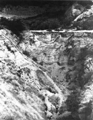
Erosion at Keet Seel Navajo National Monument
Photo: National Park Service
Archaeologists postulate that there were at least two plausible explanations:
1. They experienced a prolonged drought which destroyed their crops and left them with a severe shortage of water.
2. The area became deforested because of their land practices, and the subsequent erosion and arroyo cutting gradually, over time, reduced the tillable land available to them.

Navajo Winter Hogan
Photo: Wikimedia Commons
It is thought that the Navajo people moved into the area around 1400 and 1525 A.D.
They, too, had been nomadic people but unlike the Anasazi who built elaborate pueblos, the Navajo built individual homes or Hogans as they called them, pentagonal structures constructed from wooden poles, tree bark and mud.
Although the Navajo lived in relatively close proximity to the cliff dwellings and knew of their existence, they avoided them out of respect for the spirits who thought to still inhabit them.
And thus, where once there had been the sights and sounds of people at work and play, there now remained only silence.
That is, until January 1895 when Richard Wetherill, a rancher from Mancos, Colorado came upon them.
This is the same Richard Wetherill who discovered Cliff Palace Ruin while in search of a stray calf in the Mesa Verde region of southwestern Colorado in December 1888.
He became obsessed with finding more of these lost civilizations and over the next several years he found, explored and excavated several more sites which had rested undisturbed for centuries.
One of these was Chaco Canyon in New Mexico, which probably more than anything, caused such a public outcry by archaeologists and others who believed that these sites should be protected from “pot-hunters.”
Finally in 1906, heeding these people from the scientific community, Congress passed “An Act for the Preservation of American Antiquities” which came to be known as the Antiquities Act.
This Act gave the president the authority to create national monuments from land that was threatened by speculators, land developers, the timber industry, mining companies and others.
From 1906 to the end of 1908, eight national monuments had been created, one of which was Chaco Canyon.
In January 1895, Richard Wetherill had another serendipitous moment when he and others were camped in Tsegi Canyon.
One night, his lead mule broke his hobbles and wandered off.
The next morning Wetherill followed his tracks and as he rounded a turn in the canyon there in front of him was an enormous cave with a large cliff dwelling stretching from side to side.
He and the other members of his party spent several days there mapping, surveying and excavating.
They called this ruin Keet Seel which meant,"broken pottery" in the Navajo language.
Richard Wetherill became obsessed with finding more of these lost civilizations, and over the next several years he found, explored and excavated several more sites which had rested undisturbed for centuries.

Chaco Canyon Chetro Ketl Great Kiva Plaza
Photo: National Park Service
One of these was Chaco Canyon in New Mexico, where Wetherill attempted to set up a homestead claim at Pueblo Bonito.
There was such a public outcry by archaeologists and others, who believed that these sites should be protected from “pot-hunters,” that congress was spurred to take action.
Finally in 1906, congress passed “An Act for the Preservation of American Antiquities” which came to be known as the Antiquities Act.
This Act gave the president the authority to create national monuments from land that was threatened by speculators, land developers, the timber industry, mining companies and others.
From 1906 to the end of 1908, eight national monuments had been created, one of which was Chaco Canyon.
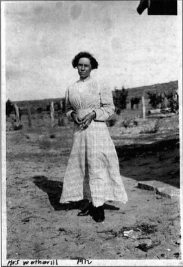
In March 1906, Richard’s brother, John Wetherill, his wife Louisa Wade Wetherill and their partner Clyde Colville established a trading post near Oljato, Utah,
Like his brother Richard, John Wetherill was keenly interested in the Anasazi and the artifacts they had left behind
|
|
|
|
John Wetherill Photo: NPS |
Louisa Wade Wetherill Photo: NPS |
Byron Cummings Photo: NPS |
In the summer of 1909 John Wetherill and his wife Louisa were working with Byron L. Cummings, a professor of classics at the University of Utah and an avid amateur archaeologist.
After working there until July, the Wetherills took Cummings, his eleven year old son Malcolm and a student photographer from the University of Utah, Stuart Young, forty miles to the west to where there was another ruin.
Inscription House Navajo National Monument
Photo: National Park Service
At the ruin they found an inscription on one of the walls which appeared to read: Anno Domini 1661. They named this ruin Inscription House.
On the way back to the Wetherill’s trading post at Oljato they learned of another ruin in the area, but they felt the horses were too tired to make this side trip.
|
|
|
Betatakin-1909 Photo: NPS |
Betatakin-1921 Photo: NPS |
A month later, on August 9, 1909, John Wetherill hired Clatsozen Benully, a local Navajo, to take a group of six to the ruin. It was a short trip, about thirty minutes, to find the ruin. They named it "Betat' akin,"Hillside House.

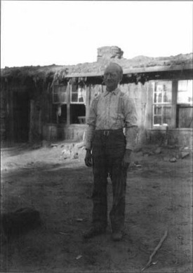
Kayenta Trading Post
Photo: National Park Service
In the fall of 1909, the Wetherills and Clyde Colville moved their trading post from Oljato, Utah south to Kayenta, Arizona, to be closer to the ruins.
John Wetherill was enlisted as a volunteer custodian, a so-called "dollar-a-year-man,"who in reality received one dollar each month to oversee both Navajo National Monument and Rainbow Bridge National Monument.
He served in that position until late in 1938 with the arrival of James W. and Sallie Brewer who were the first NPS professionals to manage Navajo National Monument.
Since there was no permanent structure at the monument, the Brewers spent the first winter at the Shonto Trading Post.

Superintendent's Residence Navajo National Monument
Photo: National Park Service
In 1939 a small two-room cabin was built near Tsegi Point at the monument which was to serve as residence for the Brewer’s as well as park headquarters.
It remained as residence and park headquarters for 24 years until a new Visitor’s Center was completed on June 4, 1964, although it was not formally dedicated until June 19, 1966.
More than 1,000 people attended the dedication, a great deal more viisitors in one afternoon than in many of the individual years in the history of the monument.
Included in these visitors were Arizona senator Barry Goldwater and Navajo Tribal Chairman Nakai.
|
|
|
Monument Museum Photo: NPS |
Blessing of Museum Photo: NPS |
The center was blessed by Navajo medicine men Floyd Laughter, Hubert Laughter and Mailboy Begay.
Over the years, there have been many such improvements at Navajo National Monument and while it cannot compare in sheer size and beauty to parks like the Grand Canyon and Yosemite, it is a hidden gem well worth getting off the beaten path to visit. Plus it is free.
If you are interested in a much more detailed history of Navajo National Monument I strongly urge you to read the references listed below.
References and Resources:
National Park Service:
Write to:
Superintendent, Navajo National Monument
HC 71 Box 3
Tonalea, AZ 86044
Visitor Information:
(928) 672-2700
Fax:
(928) 672-2703
Navajo National Monument:
A Place and Its People
Hal K. Rothman
1991
An Administrative History
National Park Service
Division of History
Southwest Cultural Resources Center
Santa Fe, New Mexico
Professional Papers No. 40
http://www.nps.gov/nava/historyculture/upload/NAVA_adhi.pdf
A BRIDGE BETWEEN CULTURES:
An Administrative History of
Rainbow Bridge National Monument
By David Kent Sproul
http://www.nps.gov/rabr/historyculture/upload/RABR_adhi.pdf


© Copyright 2011-2013. Lake-powell-country.com
All rights reserved
No reproduction allowed without permission